Sunday, November 20, 2005
New HUFF 50K 2005 Trail Map
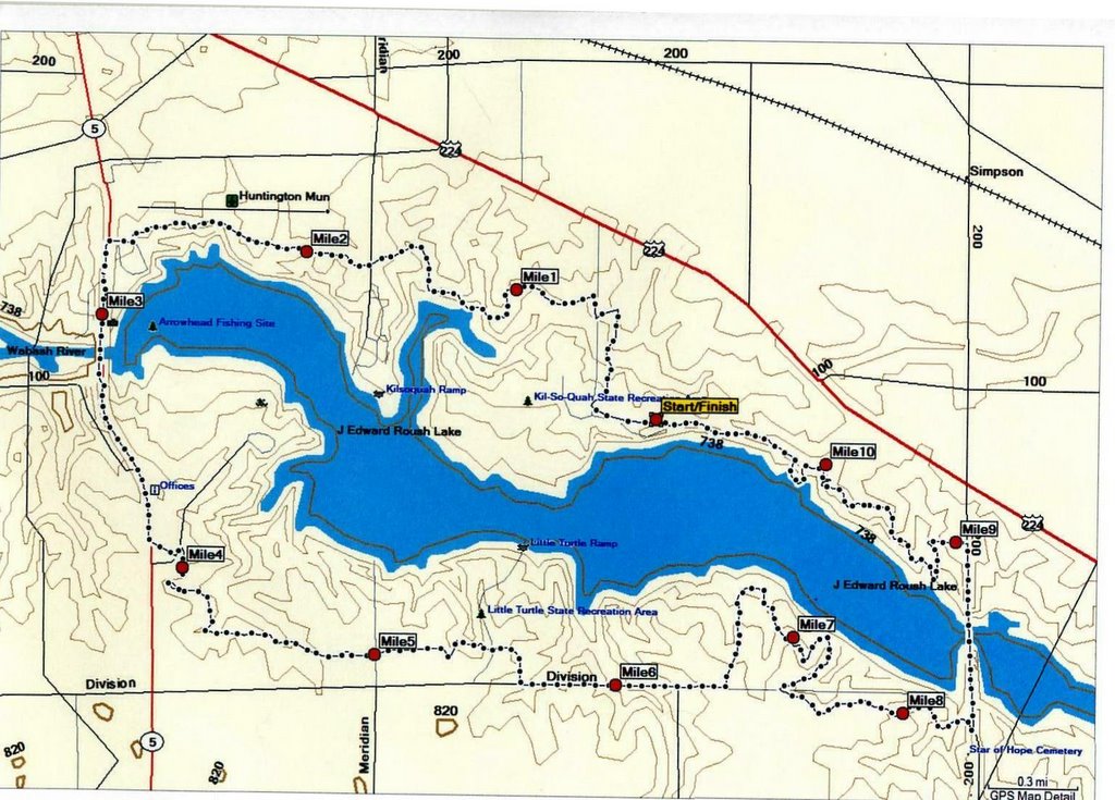 Map prepared by Jerry Diehl and Bob Berger. Course is accurately measured at 10.8 miles. (The first loop will be slightly shorter due to the road start not repeated on loops 2 and 3.)
Jerry and Bob have placed mile markers on the course on Sunday, November 20th for those doing training runs prior to December 17th.
Note that the course does not entirely follow the DNR's new Kekionga Trail. The biggest deviation is on the north side when runners are headed back west from Simpson Road (Simpson Road, aka 200E, is the eastern boundary of The HUFF course). Runners will head to the west on the old trail. Runners will not be using the newly created bike trail on that section.
# posted by Mitch : 5:02 PM

Comments:
<< Home
Mitch, thanks for posting. This is very helpul. Having run the one lap race last year, I can visualize the course nicely. Thanks for putting this level of detail on line!
Looking forward to Dec 17th!
Looking forward to Dec 17th!

I went out two weeks ago and did a loop plus part of a second. My running partner said that the course had been temporarly altered due to hunting season. Is that true? She said that the course was now around 12 miles for the loop. I am heading out this Saturday and I want to know if it is around 12 miles or the 10.8 miles. Thanks for the input.
# posted by  : 1:10 PM
: 1:10 PM
The 2005 course is 10.8 miles.
The course has been designed and measured by Jerry Diehl and Bob Berger. The first loop on the day of the race will be slightly shorter due to the start on the road.
The course has not been altered for hunting. It has been altered by the DNR for two reasons. The first is an alteration required by the terms of the grant for the new, state-of-the-art shooting range on the south side of the course. The grant required a greater safety zone around the range.
The second reason is to get the trail, as much as possible, out of areas that flood. There have been three periods of extensive flooding on the upper Wabash in recent years.
The course is now marked with signs showing the HUFF course. There are two substantial alterations from the new Kekionga Trail. One is on the south side after the asphalt road leading to the boat ramp on the south side of the reservoir. Runners will go straight after crossing the boat ramp drive. Do not take the new trail to the left. Once it rejoins the new trail you will then go right to road. Runners will then take a short road section until just past the new firing range. Runners will then enter the woods to the left on the new trail.
On the north side, once a runner has started going west on the trail after crossing the Simpson Road bridge (the east boundary of The HUFF course, the HUFF runner will not go on the trail to the right. Keep going straight and run down the hill into the low area. Simpson Road back to the Kil-So-Quah Campground will all be on the original HUFF trail.
Post a Comment
The course has been designed and measured by Jerry Diehl and Bob Berger. The first loop on the day of the race will be slightly shorter due to the start on the road.
The course has not been altered for hunting. It has been altered by the DNR for two reasons. The first is an alteration required by the terms of the grant for the new, state-of-the-art shooting range on the south side of the course. The grant required a greater safety zone around the range.
The second reason is to get the trail, as much as possible, out of areas that flood. There have been three periods of extensive flooding on the upper Wabash in recent years.
The course is now marked with signs showing the HUFF course. There are two substantial alterations from the new Kekionga Trail. One is on the south side after the asphalt road leading to the boat ramp on the south side of the reservoir. Runners will go straight after crossing the boat ramp drive. Do not take the new trail to the left. Once it rejoins the new trail you will then go right to road. Runners will then take a short road section until just past the new firing range. Runners will then enter the woods to the left on the new trail.
On the north side, once a runner has started going west on the trail after crossing the Simpson Road bridge (the east boundary of The HUFF course, the HUFF runner will not go on the trail to the right. Keep going straight and run down the hill into the low area. Simpson Road back to the Kil-So-Quah Campground will all be on the original HUFF trail.
<< Home
![]()